


 The Town Park Challenge runs on the Sporteering App developed and released recently by Polaris. Sporteering is designed to allow participants to explore towns and green spaces across the country by challenging them to find and capture points marked on a map and collect points when they reach each one.
The APP utilises GPS and smart phone technology to allow organisers to create events to showcase their city, town, trails and green spaces with active walking, running or cycling challenges.
So how does it work? The best introduction to the way in which it operates is contained in two short videos. The first one (https://vimeo.com/246250343) explains the registration process and the second (https://vimeo.com/248457615) covers taking part in a challenge. Have a look at those as a first step and then download the App and register.
Once you are registered you will need to find the Town Park challenge in the list of events. Log on the the App and click the “events” tab. Scroll down to find the Telford Town Park Christmas Challenge. Bear in mind that the list is in date order not alpha – our date is 15/12/17. Once you click the Town Park challenge you will have access to the two main screens for the event – the map showing the control points and the scan screen. With the map you can choose whether to view as a satellite or a traditional map view and once you are in the park you should also see a small blue circle showing your own current location. And you can of course zoom in to see the exact location of each control point.
So now you are ready to begin. The start and finish point is the Visitor Centre. Just go up to the front of the Centre and press ‘Scan GPS”. Ignore the instruction to ‘Scan first QR code” as we are not currently using any QR codes. We may do so later but at the moment our challenge is entirely GPS based.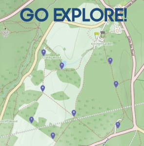
You should now get a “success” message which tells you that all the control points are now live and you have two hours to find them in any order. At each point just press “scan GPS” and you should get a success response. If you get a “failed” response just move position until you succeed. Your phone should recognize the control point if you are within 20 metres of the position but the accuracy of individual phones does vary so in some cases you may have to get your blue dot right on the marker on the map. Once you have captured all the control points return to the visitor centre and scan GPS again. That will stop the clock and will allow you to upload your timing and your points score to the Sporteering web site. If you fail to return to the Visitor Centre for this second scan the clock will keep running to give you the maximum time allowed (2 hours for this particular challenge).
You can do the challenge as a walk, a run or a cycle ride. All the the control points should be easily accessible for pushchairs and wheelchairs and none of them are inside buildings or areas of the park which are locked at any time.
Enjoy the challenge and if you have any comments or suggestions to offer do please feel free to drop an email to cthompson@bcs.org.uk. This is the first of these challenges that we have offered and if it is successful we hope to make it a regular feature.
Have fun
Colin Thompson
