


The Town Park Sporteering Challenge runs on the Sporteering App developed and released recently by Polaris. Sporteering is designed to allow participants to explore towns and green spaces across the country by challenging them to find and capture points marked on a map and collect points when they reach each one.
So how does it work? The best introduction to the way in which it operates is contained in  two short videos. The first one (https://vimeo.com/246250343) explains the registration process and the second (https://vimeo.com/248457615) covers taking part in a challenge. Have a look at those as a first step and then download the App and register.
Once you are registered you will need to find the Town Park Easter challenge in the list of events. Log on the the App and click the “events” tab. Scroll down to find the Telford Town Park April Challenge. The list is in date order and our date is the 9th March 2018. Once you click the Town Park challenge you will have access to the two main screens for the event – the map showing the control points and the scan screen. With the map you can choose whether to view as a satellite or a traditional map view and once you are in the park you should also see a small blue circle showing your own current location. And you can of course zoom in to see the exact location of each control point.
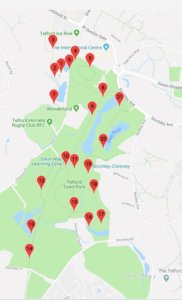 So now you are ready to begin. The start and finish point is the Visitor Centre. Just go up to the front of the Centre and press ‘Scan GPS”. Ignore the instruction to ‘Scan first QR code” as we are not currently using any QR codes.You should now get a “success” message which tells you that all the control points are now live and you have two hours to find them in any order.
At each point just press “scan GPS” and you should get a success response. If you get a “failed” just move position until you succeed. Your phone should recognise the control point if you are within 30 metres of the position but the accuracy of individual phones does vary so in some cases you may have to get your blue dot right on the marker on the map.
Once you have captured all the control points return to the Visitor Centre and scan GPS again. That will stop the clock and will allow you to upload your timing and your points score to the Sporteering web site. But keep track of the time – if you go over the 2 hour time limit you will incur penalty points so you might want to return to the finish point at the 2 hour mark even if you haven’t captured all the GPS points. The clock does of course keep running until you scan the Visitor Centre point for the second time so try to make sure that your route gets you back there in good time.
You will notice that the scores vary between the GPS points – essentially those furthest from the Visitor Centre carry the highest scores. But that does mean that you need to plan your route to maximise your score. And just to make things a little more difficult the individual scores for the GPS markers are not shown until you scan the start point.
You can do the challenge as a walk or a run. All the the control points should be accessible for pushchairs and wheelchairs and none of them areinsidebuildings or areas of the park which are locked at any time.
Enjoy the challenge and if you have any questions, comments or suggestions to offer do please feel free to drop an email to cthompson@bcs.org.uk.
Have Fun
Colin Thompson – Friends of Telford Town Park
